How to Use

View mode

This mode is designed mainly for government personnel related to climate change, and has the 3 functions shown below:

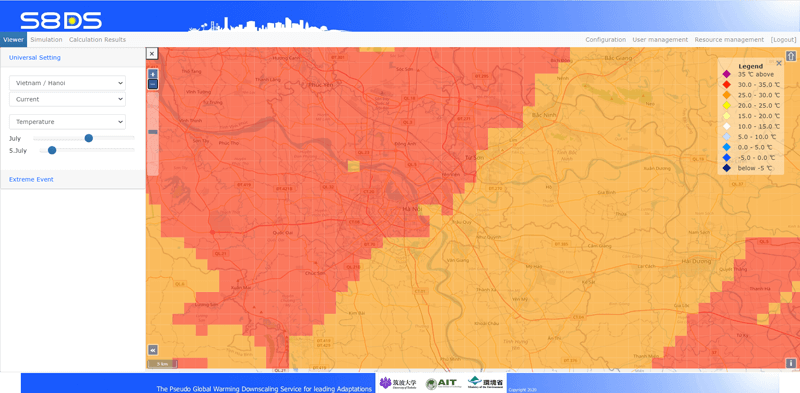
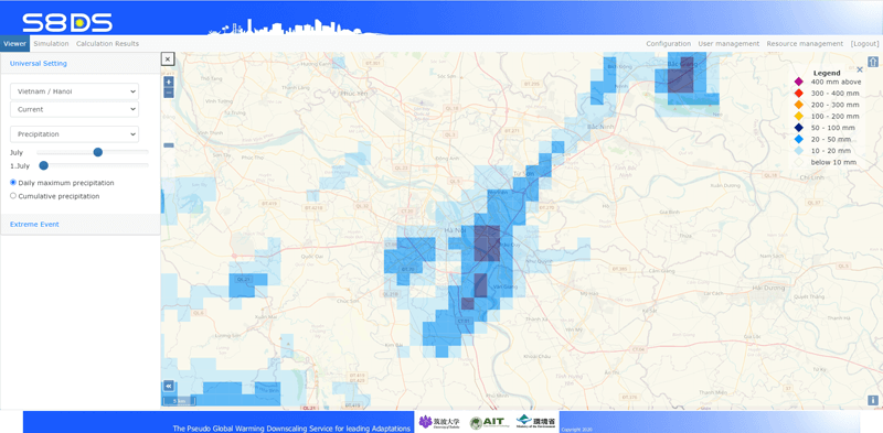
1. Universal settings

Downscaled climate projection data can be viewed for a hypothetical year with no natural disasters. The University of Tsukuba will upload simulation data for Hanoi and Bangkok by March 2021.

2. Extreme events

Using climate data from past disasters (typhoons, floods, droughts), future data (end of 21st century) and differences between past and future data can be viewed.
The University of Tsukuba will upload simulation data for a typhoon in Vietnam, a flood in Thailand, and a drought in upstream regions of the Mekong River by March 2021.

3. Sharing (under construction)

System administrators will be able to display selected simulation results in View mode, as needed.

Simulation mode

The simulation mode is mainly for experts and engineers concerned about climate adaptation. This function is to set conditions for downscaling to calculate future data in accordance with the following 5 steps.

1. Area settings

To set the country, city and resolution/region of RCM.

2. Objective settings

To set the purpose to calculate projection data.

3. Simulation properties

This is to set past climate data and simulation period. To compare with a past disaster, choose the year and month the disaster occurred (e.g., August 2011 for flooding in Bangkok).

4. Land use, urbanization level (optional)

To set a modified land use, urbanization level, and anthropogenic heat.

5. Scenario settings

To set a GCM/RCP and target projection date (i.e., mid- or late-21st century).

Calculation results mode

This is a function to view the results of the simulation.
Past, future, and differential data can be viewed via web-based GIS.
If necessary, past and future data can be downloaded in CSV or NET-CDF format.

Terminology

Global Climate Models (GCM)

Global climate models (GCMs, also referred to as general circulation models) are used to simulate complex interactions between the atmosphere, oceans, land surface and cryosphere and include variables such as temperature, precipitation and wind. GCMs are calculated over a three-dimensional array of grids covering the globe.

Many climate change experiments have been performed with GCMs.
Four criteria for selection of which GCM output to use for an impact study have been suggested: vintage, resolution, validity, and representativeness of results.
GCM predictions of climate change may depend upon the choice of point on the control run at which increasing greenhouse gas concentrations are introduced.

Regional climate projections done by downscaling generally depend on GCM selection.
The S8DS service uses the “GCM ensemble” approach.
Multiple GCM results can be averaged together in an ensemble to provide a more robust estimate of climate change.

Representative Concentration Pathways (RCPs) scenarios

Climate projections are made by running GCMs with prior assumptions about patterns of greenhouse gas emissions. These are referred to as Representative Concentration Pathways (RCPs).

RCP 2.6:

a low scenario that assumes major reductions in emissions and shifts in climate policies, involving action by both developed and undeveloped nations

RCP 4.5:

a moderate scenario where emissions peak around mid-century and then decline rapidly over the second half of the century

RCP 6.0:

a moderate to high scenario, stabilizing after 2100 at 4.2 and 6.0 W m–2, respectively

RCP 8.5:

the highest scenario, which assumes that we continue on the approximate climate trajectory we are currently on - often referred to as “business-as-usual”

Climate downscaling

Climate downscaling is a method to create spatially detailed climate data from GCM outputs having coarse spatial resolution.

It is a kind of interpolation to consider impacts on the regional climate, including precipitation, humidity, temperature, etc.

Climate downscaling is used for a defined area and considers detail topographic and land-use influences on the regional climate.

Three methods for climate downscaling (DS): Comparison of performance

Pseudo Global Warming Method

The pseudo-global warming method is a well-known approach for dynamical downscaling to reduce GCM bias.

A pseudo-future climate is created by combining current climate (reanalysis data) and the signal from GCMs (projected values), then downscaled to produce future regional climate projection data.

Regional Climate Model (RCM)

A Regional Climate Model (RCM) is used with GCM outputs to create higher spatial resolution data via dynamical downscaling. RCMs can simulate the past or predict/project the future regional climate. They require spatially detailed topography and land-use datasets as input data, as well as initial and boundary conditions (which are generally created from GCM outputs).

Technical points (advanced)

Future improvements in climate downscaling

Climate change impacts in urban areas have been influenced by both global climate change and local urbanization during the past several decades, especially in major Southeast Asian cities.

Both warming trends are expected to continue in the future.

However, most climate downscaling studies to date have not considered future changes in land-use and anthropogenic heat release, so further research is needed in this area.

How to modify land use settings in S8DS

Select “Land use planning” in “2. Declaration of Purpose,” and then click “4. Land use, urbanization and anthropogenic heat.”

Default land use data can be viewed by clicking any of the “View” buttons for current or future (after global warming) default values, as shown in the figure on the left.

Users can download default land use data (net-cdf format), modify it using GIS or Python code, and then upload the results.

*Note: Users with other land use data are asked to please confirm in advance that it is compatible for uploading via WRF program (which is used by the S8DS service).

How to modify anthropogenic heat settings in S8DS

Main parameters for anthropogenic heat settings are as follows:
- Industry (power plants, incineration plants, factories)
- Buildings (air conditioning, other electric equipment, gas heating)
- Vehicles (engines, air conditioning)

Default scenarios of “Business as Usual (100%),” “High Development (120%),” “Slow Development (80%),” and “Custom” can be selected.

The default parameters are estimated based on cities in Vietnam, but may not be appropriate for other countries.
For more appropriate and detailed parameters, please consult with urban heat island specialists in the respective country.

How to modify urbanization ratio settings in S8DS

Default scenarios of “Business as Usual (100%),” “High Development (120%),” “Slow Development (80%),” and “Custom” can be selected.

The default parameters are estimated based on cities in Vietnam.

However, they may not be appropriate for cities in other countries.

For more appropriate and detailed parameters, please consult with urban heat island specialists in the respective country.